 |
Arborfield
|
|
Properties
Related sites:
NOTE: The Infant and Junior schools have now amalgamated under the name 'The Coombes C.E. Primary School' Arborfield's Street Names, listed in alphabetical order, with their derivations Aerial Photos of Arborfield and Newland in the 1940s and 1961 Proposals for By-passes to cure traffic problems The River Loddon - was it once a navigable waterway?
|
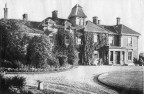
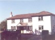
The Manor of Arborfield has changed hands a few times over the last 1,000 years - click here for more details. In 1900, most of the land in Arborfield was in the hands of four large estates, Arborfield Hall, Swallowfield Park, Newlands and Bearwood. See also the Auction page. However, there were many smaller buildings that were owned independently at the time. Arborfield Hall Mary Mitford, in her book 'Our Village', called the Hall 'Aberleigh', and hence Reading University gave this name to the 1960's house that replaced it. Sir John Conroy died in 1854 and the estate was sold in 1855 to John Hargreaves, as shown in the Auction pages. The Seat of Sir John Conroy, Bart., 1850-1859. On the Hall Estate by the River Loddon was the Mill, which produced paper. The ground floor still exists today, albeit heavily disguised. Also, we have a photo dating from 1906 showing some heavily-dilapidated Tudor cottages. Click here to see them - at the end of the web page on the 1855 Auction. See also the 1919, 1924 and 1926 Auctions for photos and descriptions of the Hall and its grounds. The hall was taken over during WWII, first by the R.A.F. and then by the US Army Air Force, as described here. After WWII, Arborfield Hall Camp was then used for temporary housing until the new Council Estate of Anderson and Emblen Crescents was completed in the early 1950's. To see a comparison of what the grounds of Arborfield Hall looked like when still owned by the Hargreaves family and how they looked in 2011, click here. Newlands
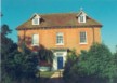
Arborfield Grange The Grange, originally a farmhouse, was owned by George Dawson in the 1840's, who remodelled it and the surrounding roads to suit his needs. By 1840 the property had grown and was known as 'The Cottage' and later 'Arborfield Cottage' (as can be seen by George Dawson's advertisement for a tenant). By 1869 it had become 'Arborfield Grange'. When Sir John Conroy, 1st Baronet, left royal service, he moved to 'The Cottage'. Later, when George Dawson sold Arborfield Hall, after it had been rebuilt, with his finances strained, Sir John bought the Hall. His son Edward moved into Arborfield Cottage. He lived in the then 'Arborfield Grange' until his death in 1869. Sir John Conroy, 3rd Baronet, then took the property over, although Lady Alicia Conroy (wife of Sir Edward) was still living there and did so into the 1880's. Sir John was still the owner in 1883, even though he almost exclusively lived in Oxford. By 1887 a Surgeon General, Henry M. Cannon had become the owner. It would appear that Lady Alicia did not die in Arborfield. The article on Arborfield Grange includes a list of owners, plus some photographs from a 1920's Sale document.
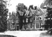
Arborfield Court This mansion was erected between 1900 and 1909 on the top of a hill south of Arborfield Cross. When it was being built, workmen found Celtic pottery remains. Was this the site of an ancient burial mound? There is an image of the property when new from Reading Local Studies Library. In addition, the Library also has floor plans and interior views which you can see from here. The property was later split up into several apartments, each owner having their own section of garden.
Bearwood The Bearwood mansion and its grounds are largely within the Liberty of Newland, and the residents of the School still come within Arborfield Ward for local elections. The estate was put together by the proprietor of 'The Times', John Walter, and he re-modelled Sindlesham as a model village around a green. Click here for more details, including a description of the area in the 1600's. The Bearwood Estate extended through Barkham down to Nine Mile Ride, and some was sold off to become the Remount Depot (later to become Arborfield Garrison). The Estate was put up for Auction in 1911. During WWI, the mansion was used as a Convalescent Hospital for Canadian troops, and in 1922 the mansion became the Royal Merchant Navy School for the orphans of merchant seamen. It is now an independent school, known as Bearwood College. The Estate Maps reveal a huge amount of information about the parishes of Hurst and Arborfield - click here for details. The Estate was fully described in the 1911 Auction Sale document. John Walter owned Cross Lanes Farm, on the Reading Road - click here for information on this farm.
Arborfield Garrison By 1939 the site had been transformed into the Army Technical School (Boys), taking the name 'Arborfield Garrison' because the main entrance was in the Parish of Arborfield. The Guardroom and Garrison shops were on the west side of what is now Bramshill Close as shown here. For a bigger image, click here. To read about the hsiotory of the married quarters at the Garrison, click here. Housing for employees and later married quarters, For more information on the Apprentices' College, which finally closed in August 2004, click here. The R.E.M.E. Museum web-site gives a lot of information on the Royal Electrical and Mechanical Engineers' connection with Arborfield.
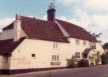
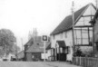
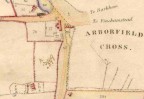
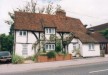
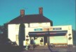
Swallowfield Park This estate owned several farms in Arborfield Parish, namely Bartlett's and White's Farms on Swallowfield Road, Duck's Nest Farm on Eversley Road, and New Farm on the Reading Road. Other Properties A group of buildings had already been established at, or near, the crossroads by the c15, with the two coaching inns creating a centre for trade for the local farming community and travellers. This now forms the nucleus of the Conservation Area. Arborfield Memorial Cross has an owner, or at least a Trustee, namely the Royal British Legion. It was first erected in 1919 and it was further modified after the Second World War. Click here to learn more.
Just outside the parishes but within staggering distance were the Fox P.H. at Sindlesham (long since gone - see at the top of the Bearwood map section linked here), and the Magpie and Parrott on the Reading Road south of Shinfield, which re-opened a few years ago. Even when closed, the faint outline of the pub's name could still be read, showing the brewery (Simonds).
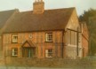
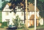
Carter's Hill has at least two distinguished properties. One is half-timbered and named Tudor House, originally part of Carter's Hill Farm, but which has been enlarged during the 20th Century.
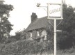
The Targett and Allwright families had a long association with Targett's Farm on Langley Common. It was still being managed as a unit until at least the 1920's. However, the Farmhouse and cottage were subsequently let out, and Miss Jervoise lived in the Farmhouse in the 1940s.
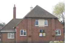
Elisha's Farm became the site of the new St. Bartholomew's church in 1863. Kenny's Farm near Magg's Green on the border with the parish of Swallowfield is many centuries old, and still has a moat. There used to be many farm out-buildings as shown on the Tithe Map of 1839, but most were demolished by the 1970's. An old map showing Kenny's Farm and the nearby ancient 'Bound Oak' can be seen by clicking here. Pound Copse off Greensward Lane is now owned by Arborfield and Newland Parish Council. Read the article from 'Your Village' 1983 by clicking here. The Village School in School Road was connected with Arborfield Parish Church, and covered not only Arborfield and Newland but also the neighbouring parish of Barkham. It taught all age-groups until new Secondary Schools were built in Wokingham, followed later by the Coombes Infant School, so that it then taught only from ages 7 - 11. The school served as a meeting-place for Newland Parish Council and Arborfield Parochial Church Council for many years. At its peak in the early 1960's, there were several temporary buildings in the playground next to School Road. In September 2008, the two schools have amalgamated under the name 'The Coombes C.E. Primary School'. The Whitehall Brick and Tile Works have long since disappeared, to be replaced by the 'Badger's Mount' development. For a quick trip around Arborfield's streets, lanes and byways, listed in alphabetical order with derivations of their names where known, click here.
|
||
| Any Feedback or comments on this website? Please e-mail the webmaster |