
|
Arborfield
|
|
Census data
Related sites:
Parish Registers: Baptisms: Baptism Index: Marriages:
1580-1641 Marriage Index: Burials: 1580-1600 Burial Index: Civil Electoral Registers: 1871
The effect of the Motorways on the growth of Arborfield and its surrounding area
|
We can build up a big picture of everyday life in Arborfield and Newland through the 19th Century from Census data. From 1841, Census returns have been kept and are available in microfiche or microfilm format from Local Studies Libraries and the Berkshire Record Office. The Census returns for Arborfield are easy to find; however, those for Newland are buried among those for Hurst, while the few addresses for the detached portion of Wokingham are like a needle in a haystack. This little 'peculiar' of Wokingham was bounded by an elongated triangle between what are now Ellis Hill Farm, the Junior School and the cottages on the corner of School Road and Coles Lane. Arborfield Local History Society has extracted the data from every Census from 1841 to 1901 inclusive, and has indexed it for easy access, along with other data as shown below. 1841 census: Index Arborfield Parish Liberty of Newland Wokingham Parish (detached) 1851 census: Index Arborfield Parish Liberty of Newland Wokingham Parish (detached) 1861 census: Index Arborfield Parish Liberty of Newland Wokingham Parish (detached) 1871 census: Index Arborfield Parish Liberty of Newland Wokingham Parish (detached) 1881 census: Index Arborfield Parish Liberty of Newland Wokingham Parish (detached) 1891 census: Index Arborfield Parish Liberty of Newland Wokingham Parish (detached) 1901 census: Index Arborfield Parish Liberty of Newland Wokingham Parish (detached) Master Surname Index covering all 60 years - that's at least two generations of the same family: A-B C-D E-G H-K L-M N-R S-V W-Z The 1911 Census, which is far more detail, is widely available on Family-History web-sites. More recently, the 1939 Register has been published, showing who lived in the area at the beginning of World War II. It was amended over the War years and into the late 1940s, especially to record married surnames. At the time of publication in 2015, a significant proportion of names were 'redacted' (made unreadable) because the people were thought to be still alive - though this wasn't completely accurate, but that's not surprising among at least 40 million records.
Parish Registers Click here to see Baptisms, Marriages and Burials from 1580 up to the first part of the 20th Century, from all available Registers, including Bishop's Transcripts up to 1837. All are fully indexed by Surname. Most of the residents of the Liberty of Newland appear to have used St. Bartholomew's as their parish church, even though Newland was in Hurst, and latterly part of Bearwood, until the 1970's. The 'Terrier' from the 1839 Tithe Apportionment Map for Arborfield. Banns of Marriage, Parish of Arborfield 1929-1975, plus Alphabetic Index (nearly 1000 names). Register of Services 1951-1959, containing details of Baptisms, Weddings, Funerals and other special services, plus comments. Dissenters' Baptisms, Arborfield Cross, 1759 - 1836. First two years of the Parish Magazine, January 1877 - December 1878. The Registers in use at the time were stolen along with the Church Safe in 1975, but we have pieced together nearly all of the 'missing marriages' from 1837 to 1973.
Civil Electoral Registers for Arborfield and Newland (more years can be seen on microfiche at Berkshire Record Office): 1871, 1889, 1894, 1905, 1913, 1920, 1928, 1939, 1946, 1950, 1953, 1960. In addition, the Terrier accompanying the 1839 Tithe Apportionment Map for Arborfield shows the ownership and occupation of each plot of land as it was in 1891.
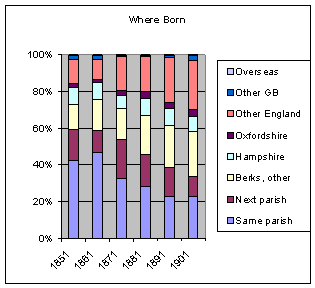
The Census data show that the population varied only slightly from the mid 500's to a peak of around 670 in 1871, declining to the mid 500's by 1901. On the other hand, its composition changed markedly over time, as these two charts illustrate. The first shows that an increasing proportion moved from further afield as transport got easier:
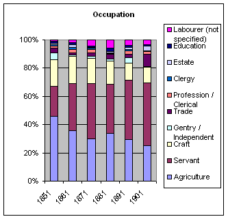
The second shows that the pattern of employment shifted towards domestic service by 1901. Things have changed much since then!
Recent Census Data Since 1945, Berkshire's population has grown explosively, and so has the number of dwellings, particularly in Earley, Woodley, Wokingham and Winnersh. Click here for details on how the district has grown. Arborfield bucked the trend in 1971 and 1981, because Poperinghe Barracks was being demolished and the young soldiers were being re-housed in Rowcroft Barracks, in Barkham. Arborfield's loss became Barkham's gain! The 1991 Census gave a lot of detail which can be viewed at the Berkshire Record Office, but here is a brief summary:
In 2001 the Arborfield population didn't increase much, but 2011 gave a very different story, because the Penrose Park estate, Gerring Close and the Poppyfields estate were completed. In addition, partially-empty military houses in Valon Road and in Barkham Parish were sold off, and found many ready buyers. Since then, the Army has moved out of Arborfield with the REME moving to Lyneham in Wiltshire - and something like 3,500 houses are planned to be built at what's now known as 'Arborfield Green' by 2026.
|
|||||||||||||||||||||||||||
|
Any Feedback or comments on this website? Please e-mail the webmaster |