|
Arborfield
|
|
Properties
Related sites:
Aerial photo of Eversley Road, the 'Bramshill Hunt' P.H. and Poperinghe
Barracks, The Garth Hunt, successors of the Bramshill Hunt from 1852 onwards
Web-site
of the Vale of Aylesbury with the Location of the 'Bramshill Hunt' on the 1837 Tithe Apportionment Map The following postcards from the H. A. Giles collection, are viewable on the Reading Local Studies Library web-site:
|
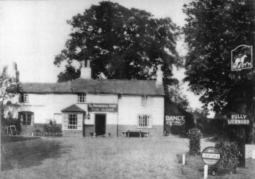
When the A.327 became the Garrison By-pass in 1969, the old Eversley Road was severed where it passed through the Garrison. The middle part became 'Bramshill Close', and the southern part became 'Sheerlands Road'. North of Langley Common Road is now 'Rickman Close'. The pub had long been associated with the Garrison. It is close to the old Remount Depot, and it is just along from the site of the entrance to Poperinghe Barracks. It was by far the closest pub to the now-closed Army Apprentices' College. Poperinghe Barracks is long since demolished, and much of the site is occupied by the Penrose Park development. This slightly blurred photo shows that the pub was licensed not only for drinking, but also for dancing (If you have a sharper historical image of the pub, please contact the Society!).
The Bramshill Hunt itself had ceased under its own name as far back as 1850, but most of the 'country' that it used to cover was taken over by the Garth Hunt, whose meetings, both in Arborfield and in the wider area, were regularly reported in the 'Reading Mercury'. Both the Garth Hunt and the Farley Hill Beagles started some of their 'meets' at the pub. This photo is from the 'Reading Mercury' of October 10th 1931, showing the Farley Hill Beagles alongside the 'Bramshill Hunt' (as announced the previous week under 'Hunting Appointments'). The caption was: 'Young and old interested in the pack of the Farley Hill Beagles at the first meet of the season, held at Arborfield on Saturday'. (Photo: 'Reading Mercury'; credited to P. O. Collier).
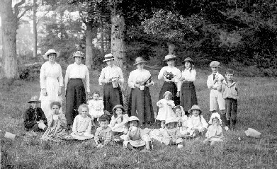
Behind the 'Bramshill Hunt' used to be part of the old Wokingham Lane, which has disappeared under the Tarmac of Baird Road. Thanks to Alice Allen, we have a photo from the 1910's of a picnic held along Wokingham Lane just behind the pub. Click on it for more detail. Wokingham Lane used to continue from this point south-east of Arborfield, towards 'Bound Oak' on Castle Hill, Farley Hill.
The 1841 Census listed the 'Bramshill Hunt' as an Inn, with Anthony Cole as 'Beerseller'. However, Anthony had been there for some years. When the 1837 Tithe Apportionment Map was drawn up, his dwelling was simply described as a 'cottage and garden', owned by William Cordery. By 1851, Anthony Coles [sic] was only a labourer, while his wife Ann was the beer seller. Charles Clacey was the publican for many years, appearing in the 1861, 1871 and 1881 Census returns, but by 1891 he was a widower living nearby at Langley Common, while Richard Whitley was at the inn, combining the occupations of publican and blacksmith. Charles died in 1898, and is buried with his wife Annie at Arborfield. Kelly's Directories show that Thomas Kelly was landlord in 1895 and 1899 (and in the 1901 Census), then William James Rapley in 1907 and 1915; William died in December 1926, aged 63. John Henry Allen had taken over by 1929, followed by William Kent , as recorded in the 1935 edition.
|
||
|
Any Feedback or comments on this website? Please e-mail the webmaster |

