
|
Arborfield
|
|
Properties
Related sites:
1944 Close-ups:
Modern
|
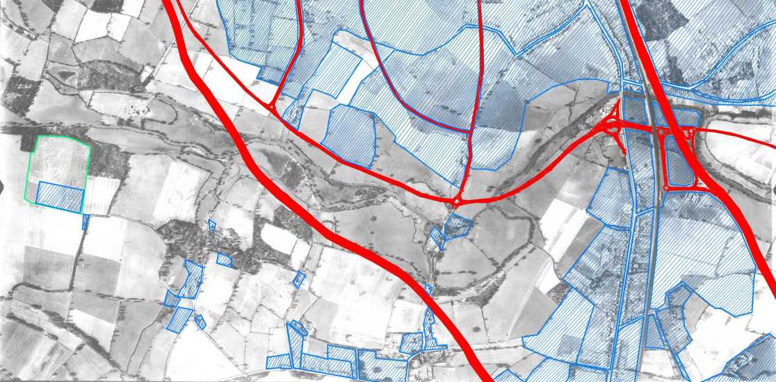
How the Motorways affected Winnersh, Earley & Woodley The USAAF aerial photo of Carter's Hill and Winnersh, dated 8th March 1944, ref. 5045, is reproduced by permission of National Monuments Record, English Heritage.
Berkshire County Council Planning Committee Minutes held by the Berkshire Record Office reveal the enormous pressure for housing in Berkshire in the later half of the 20th Century, and how the coming of the M4 and A329(M) increased this pressure. The route of the M4 was hotly contested. The first part had been completed as the Maidenhead Bypass in 1959. Construction actually started in the late 1930's with the erection of bridge parapets at the River Thames crossing at Bray, but World War II and post-War reconstruction changed priorities for many years. In 1946, details of the London and South Wales 'motor road' were published; it was to extend westwards from the Maidenhead Bypass through Winnersh, Shinfield, Grazeley and then south of Newbury and Hungerford. However, the plan was ditched for at least a decade, by which time, the route was intended to pass through south Oxfordshire towards Swindon rather than south of Reading and Newbury. By 1964, the M4 was extended eastwards from the Maidenhead and Slough Bypasses with an elevated section that merged with the already-existing Chiswick Flyover. It was intended to proceed north-westwards from Maidenhead Thicket through South Oxfordshire, but there was a last-minute change to the plans in the late 1960's, which were to have far-reaching effects. Once the line of the M4 had been diverted away from Oxfordshire to pass south of Reading, a Relief Road was planned for the north of Wokingham, to be built to motorway standard. There was a lot of discussion about junctions, including one on the A321 immediately to the north of Wokingham at Ashridge Farm, another at Winnersh, and a third to the east of Earley. In the late 1960's, Berkshire County Council formed the Woodley / Earley Steering Committee to consider new housing. The new relief road, to be called the A329(M), was intended to be the catalyst for this development. As it happened, only the Winnersh interchange was built. The following Minutes recorded the Planning Inspector's decision regarding the Ashridge Interchange: Ref. C/CL/C3/21/10 14th January 1971 Highways & Bridges and County Planning Joint Special Section: Item D/I/10 Reading / Wokingham / Bracknell Road (A329) Relief Road Scheme: ‘Para. 279’: A detailed study of the road and traffic conditions and improvements of Wokingham and neighbourhood has not yet been made. Objectors urged that a decision on whether the Ashridge Interchange should be provided, should not be made until a study had been carried out. They argued that the need for such an interchange, or indeed, for any interchange between Amen Corner and Winnersh had not been proved. They were anxious that ‘through’ traffic from whatever direction, should, as far as possible, be kept out of the central area of the town and south-west and south-east bypasses were discussed with this in mind’ ‘Para 280’: On balance, I think the objectors make out a good case and that it would be premature to go on with the Ashridge or any other interchange between Amen Corner and A321, before carrying out a full investigation of the road and traffic situation in Wokingham and neighbourhood, taking into consideration the by-pass and other matters mentioned at this Inquiry. The adoption of this course of action could mean the loss possibly of the present opportunity to build an interchange for Wokingham, which the Chamber of Trade thought it essential for the town to have, and another opportunity may not readily come, even if desired, because of other competing claims on available finance. However, Amen Corner, which is only some 1½ to 2 miles from the town centre, may be found sufficient to meet local demands, and would not involve local motorists using it, in an additional net mileage of any great consequence. Some local traffic from the western side of Wokingham might use the A329 to Loddon Bridge roundabout and so pass through Winnersh ‘murder mile’. However, with the northern by-pass functioning, there might be some traffic relief to counteract this. Commenting on his Inspector’s Report, the Minister said that he accepted the Inspector’s recommendation ‘… that a decision on the need for an interchange on the line of Scheme 2 should be deferred until a thorough study of the transport needs of the area has been carried out, and that the scheme and Orders should be modified so as to delete the Ashridge Interchange from the new route'.
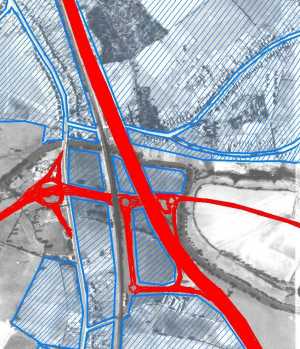
The A329(M) enclosed a large area south of the River Loddon and bounded by the railway. This became the Winnersh Triangle Industrial Estate. At the junction itself, a new road was planned to skirt the proposed Lower Earley development and cross the A327 to meet the M4 at Junction 11. Its junction with the A327 was to be on two levels, but in the event, two mini-roundabouts sufficed for a couple of decades. Its junction with the Reading Road was originally proposed on four levels, but the final result was large light-controlled roundabout with a dual-carriageway through its centre. Once the house-builders began to fill in the gaps north of Loddon Bridge Road in Woodley, its junction with Reading Road turned into a major bottleneck. Relief was at hand when the Woodley Airfield development provided the new 'Bader Way', though this now also gets very congested in rush hours. To the south of Winnersh, another major development was in the offing. Berkshire County Council's Planning Committee Minutes of December 1969 considered the following application: “Proposed development by the Land Commission, Woosehill Lane, Wokingham”. With no fewer than 25 land-owners on the 360-acre site, a Compulsory Purchase Order would be required. The Planning Officer noted:
The Officer reported: “The only satisfactory method of dealing with traffic likely to be generated on the Woosehill Site will be by means of a major access on to the existing A329, but this could only be after completion of the A329 Relief Road, and the construction of a link road between the relief road and Wokingham north of the town, in the vicinity of Ashridge Farm.” With these and other factors, the County Council officers recommended refusal since the application [for a housing site at Woosehill] was premature. Feelings ran high, as reported in subsequent Planning Committee Minutes in July 1971: Concern was expressed by the residents of the town [Wokingham] that the character and identity of Wokingham would be lost if the Woosehill allocation were permitted. It was promised to re-assess the need for Ashridge Interchange if Woosehill were implemented. Observations from the Borough of Wokingham: “The further development of Wokingham is accepted, but the recent high rate of growth there is such that the Council feels a general reluctance to accept more development in the near future is justified”. A Pro-Forma was passed unanimously at a packed Town-Hall meeting in June 1971: “This meeting opposes the population explosion for Wokingham envisaged in the County Council’s Plan for Residential development in Central Berkshire, bearing in mind that in the last ten years Wokingham’s population has expanded faster than anywhere else in the County and that the town’s services are even now quite inadequate. This meeting strongly urges the County Planning Committee not to endorse this Programme”. The Planning Committee Minutes, December 1971 reported that: "the Wokingham Society and C.P.R.E. stated that the findings of the landscape study they had commissioned led them to concur with the County Planning Officer’s assessment in selecting Woosehill [over other potential sites in Wokingham Borough]". Around this time, Planning Committee Minutes noted that Circular 10/70 “Land Availability for Planning” and 102/72 had established the pattern for 5-year land supply. If the local Planning Authorities didn't identify sites to provide for housing over a 5-year period, then property developers were entitled to appeal against planning decisions, citing the need to achieve the '5-year Strategic Plan target'. Central Government re-organisation in 1974 resulted in the merger of Wokingham Borough and Wokingham R.D.C. [Rural District Council] to form Wokingham District Council, so after this point, housing statistics are only available for the District as a whole. They hit a peak of nearly 9,000 in the 5 years between 1983 and 1988, with no fewer than 2,278 in a single year, in 1983/4. It's possible to chart housing growth from the 1930's to the end of the 20th Century using Census data, which shows how dramatic has been the change in that time. Back in 1931 there were 7,500 'structurally separate dwellings' in the area bounded by Wokingham Rural District Council including Wokingham town, and 7,303 households (some houses were empty at Census time!). By 2001, there were over 57,000 households - almost 8 times as many as in 1931:
Census data © Crown copyright 2003. Crown copyright material is reproduced with the permission of the Controller of HMSO and the Queen’s Printer in Scotland. (Note that there was no Census in 1941, and it is known that very few houses were built from 1939 to the late 1940's). This accelerated growth was made possible by the opening of the M4 south of Reading. The decision to go ahead with the Woosehill development without a direct link to the A329(M) has had a major effect on the Winnersh motorway junction, and on the Reading Road south through Winnersh, leading to the complex traffic light system at Winnersh Cross Roads. It's known that around a quarter of traffic passing through Arborfield Cross in the rush hours is headed to and from Winnersh and possibly also the motorway junction, and this was a major justification for the roundabout at Arborfield Cross. Back to aerial photo of Carters Hill and Winnersh Back to Arborfield Hall during WWII
|
||||||||||||||||||||||||||||||||||
|
Any Feedback or comments on this website? Please e-mail the webmaster |