
|
Arborfield
|
|
Properties
Related sites:
'The Poplars' - now known as Molebridge Farm
Map of Arborfield Cross from the 1947 Auction of the Newlands Estate Modern aerial photo of Arborfield Cross, courtesy of Multimap |
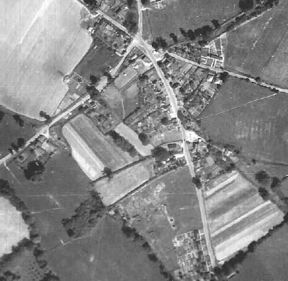
Detail from RAF aerial photo of part of the parishes of Newland and Arborfield, dated 10th July 1946, ref. 3142, reproduced by permission of the National Monuments Record, English Heritage.
This view stretches from the five-way cross-roads and the 'Bull' public house at the top southwards to 'Hillside' (now known as 'Hillcrest') on Eversley Road. The village shop and its orchards and meadow behind can clearly be seen, along with the footpath up to Arborfield Court. The Village Hall, 'Sunrise' and the 'Swan' public house can also be seen; note the length of the back gardens. Compare this photo with the map of Arborfield Cross, shown in the 1947 Auction Sale document for Newlands Estate. On the other side of Eversley Road from the Cross are the Post Office cottages, the Post Office, Birch House, the Garage, Magnolia Cottage and Whitewell Cottages. Beyond them is a field marked out in strips; this became Link Way in 1960. Between this field and School Road is another field which was being compulsorily purchased by Wokingham Rural District Council for its 'Newland Estate', finished in 1952 (now known as Anderson Crescent and Emblen Crescent). The farmer, Mr. Wade Isaac of Langley Pond Farm, Barkham, prevented Council employees from carrying out surveys on the land in the summer of 1946 until the crops had been harvested; however, they had access to the footpath running diagonally across it. The Post Office cottages' gardens stretched to School Road, which is off to the right of the picture. At this stage, the field beyond the cottages on School Road was still in agricultural use; it later became the School playing field. Swallowfield Road is off to the left, with the Parish Council cottages opposite the 'Bull', plus very few other cottages between them and Chamberlains Farmhouse, then occupied by the Goodyer family. Contrast the 1946 image with another aerial photo taken in 1985:
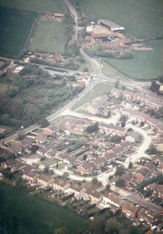
Note the scrub-land behind the 'Bull'; some quite substantial trees have grown up. Even this view is now history; the five-way crossroads is now a roundabout, while the large bungalow at the end of Chamberlain Gardens is now three detached houses and a pair of semis. Back to Aerial Photos main page
|
|||
|
Any Feedback or comments on this website? Please e-mail the webmaster |