
|
Arborfield
|
|
Properties
Related sites:
1944 Close-ups:
Modern
The effect of the Motorways on the growth of Arborfield and its neighbours
|
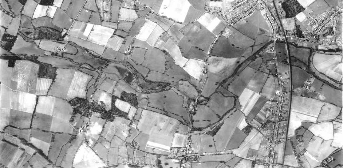
The small photo on the right shows the picture at a more familiar angle. Compare it against an Ordnance Survey map: you should be able to see Winnersh at the top, Earley to the left, Shinfield at the bottom left and the River Loddon snaking its way from the bottom left northwards to Woodley at the top left. Arborfield Hall Farm is at the bottom of the picture, while Arborfield Cross is off the picture to the bottom right. Got it yet? If not, click on the picture for a few more clues. Picture No. 5045 was part of a series of overlapping photos, and No. 5046 (not available here) shows Winnersh Cross-Roads in great detail.
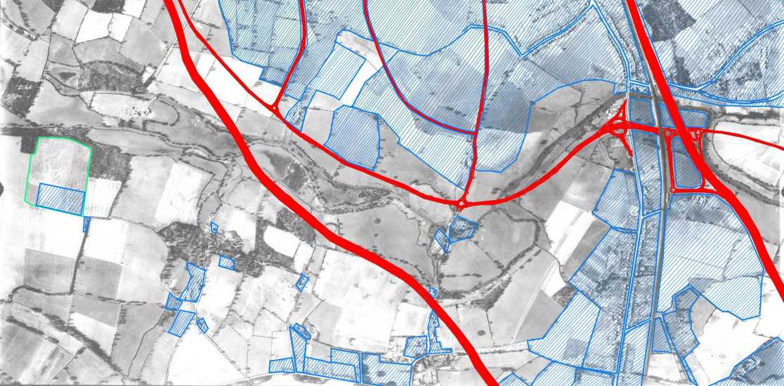
Below shows the full area covered by No. 5045, with the top-secret 'Starfish' Decoy site near the left hand edge, half-way down; the sharp edges of the woodland bordering the north of the site can clearly be seen, even at this scale. The photo covers north-east to south-west, and looks very different when compared with more recent aerial surveys. This web page allows you to compare each local area in detail between 1944 and today. Click on different parts of the photo - and use the scroll-bars to see the full detail in each close-up. Click here for a discussion on how the motorways affected the area covered by this photo.
Towards the right of this photo can be seen the northern part of Reading Road in Winnersh, with the old South-Eastern Railway line marking a very clear eastern border of the built-up area. This line had been electrified in 1939, though steam services to Guildford continued until the mid-1960's. Winnersh Railway Station had originally been built in 1910 as 'Sindlesham Halt', for the benefit of the owner of 'The Times', who lived at Bearwood Mansion just inside the Newland parish, and just off the bottom of this aerial photo. In the top right-hand corner is the edge of Woodley, while the top of the picture is now covered by Lower Earley. It is ironic that the 'Starfish' site was chosen because it was remote from housing, but now it is less than a mile from the developments of Lower Earley. From the ground, the most striking feature would have been the line of electricity pylons stretching from Earley south-westwards through Arborfield; they can be seen from the air on several of the close-up views (see left, or click on different parts of the photo above). This power line was erected in the mid-1930's, but few properties in the Arborfield area had access to Mains electricity for many years afterwards. The M4 now bisects the area covered by this view, cutting off the fields of Lower Earley from Arborfield and Carter's Hill. Just right of centre is Mill Lane, running from the bottom centre, past Sindlesham Mill, and snaking off towards the top right. The straight road to its north is Meadow Road. Loddon Bridge Road and Colemansmoor Lane can be seen in the top right-hand corner. In the bottom right-hand corner can be seen Arbor Lane, and just off the photo is its junction with Robin Hood Lane and Davis Street, now itself diverted to make way for the A329(M). The fields on the extreme right of the photo were excavated in 1969 to provide gravel for the M4 and A329(M), and now form part of Dinton Pastures Country Park. To the west of Reading Road is Westfield Road, divided in the 1960's into two parts by Chatsworth Avenue. Here is the same aerial photo, but overlaid with the modern features, such as the new main roads and all of the built-up areas. The 'Starfish' decoy site is outlined in green. Click on the links on the left to see the localities as they are now.
It's known that around a quarter of traffic passing through Arborfield Cross in the rush hours is headed to and from Winnersh and possibly also the motorway junction, and this was a major justification for the roundabout at Arborfield Cross. Back to Arborfield Hall during WWII Back to main Aerial Photo page
|
||

|
Any Feedback or comments on this website? Please e-mail the webmaster |