
|
Arborfield
|
|
Properties
Related sites:
Reading Road, Church Lane, Greensward Lane and Walden Avenue Reading Road further west to the River Loddon Arborfield Road from Shinfield to Loddon Bridge Arborfield Hall and the River Loddon Arborfield Hall Farm towards Church Lane The former 'Starfish' decoy site
Modern aerial photo of Cutbush Lane - and the M4 - courtesy of Multimaps |
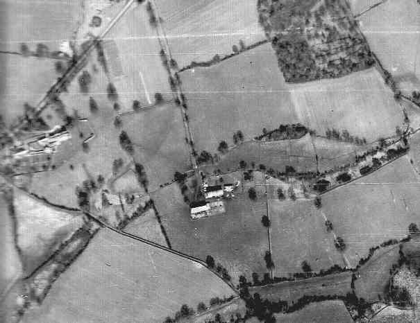
RAF aerial photo of Lower Arborfield and Shinfield, dated 10th March 1946, ref. 4042, reproduced by permission of the National Monuments Record, English Heritage.
The Shinfield side of the River Loddon seems to have escaped the heaviest Army activity. However, in this close-up, it looks as if there might have been a firing range half-way up the left-hand side. Cutbush Lane cuts across from the mid-left to the top; this was a through route until the M4 motorway was built around 1970, just to the north of this close-up. The motorway was first mentioned in Berkshire County Council Minutes in 1946, when it appeared in the Abercrombie Plan for Greater London as 'Route 2: London and South Wales via Severn Bridge'. During Summer 1946, Wokingham Rural District Council found out that the 'A4 Trunk Road' was planned to pass through Winnersh and Shinfield when its King Street Lane Council housing site had to be reduced in size to allow for the planned route alignment. This housing site later became Allnatt Avenue. Later that year, on 25th September, Berkshire County Council's Highways and Bridges Committee was told: ‘The County Surveyor reported that the Minister of Transport proposed to seek power to construct ‘motor roads’, the essential features of which would be that the roads would be restricted to motor traffic only, and that access would be obtainable at only a relatively few points. If such powers were granted the Ministry would be likely to propose that Maidenhead By-Pass should be a motor road and that branching from that road there should be a motor road passing westwards across the County south of Reading and Newbury, the latter forming part of the suggested London – South Wales motor road. ‘At the request of the Divisional Road Engineer detailed plans were being prepared for the construction of the Maidenhead By-Pass as a motor road, and investigations were proceeding for the location of the London – South Wales road through Berkshire. ‘The Ministry regard the preparation of plans for Maidenhead By-Pass as being a matter of urgency since this project would be given a high priority when labour becomes available to carry out major trunk road improvement schemes. Maps showing the tentative proposals for the motor roads in the County were exhibited at the Meeting’. This Committee was presented with a long list of by-passes at its October 1946 meeting, and it included the London – South Wales Motor Road, crossing the A329 at Winnersh, the A327 at Shinfield, the A33 at Grazeley, then Burghfield and Mortimer, crossing the border into Hampshire and back again, and continuing west past Kintbury and south of Hungerford. However, by the 1960's the planned route of the M4 was much further to the north, passing through south Oxfordshire before reaching Swindon. A last-minute change of plan saw it revert to a route through Berkshire, but now passing north of Newbury.
In the aerial photo above, note the shadows cast by the two posts in the lower right-hand corner; we can judge what time of the day the photo was taken - fairly early in the morning. Back to Aerial Photos main page
|
|||
|
Any Feedback or comments on this website? Please e-mail the webmaster |